
Y. DRYAS ICE SHEET IMPACTS
And Catastrophic Meltwater Flooding

Here are summaries of 6 of Randall Carlson’s videos about megafloods at the end of the Ice Age, caused mostly by comet or asteroid swarm impacts.
CONTENTS — FIND IN PAGE
DRUMLINS PINPOINT COMET IMPACTS
MISSOULA FLOOD FROM BRITISH COLUMBIA
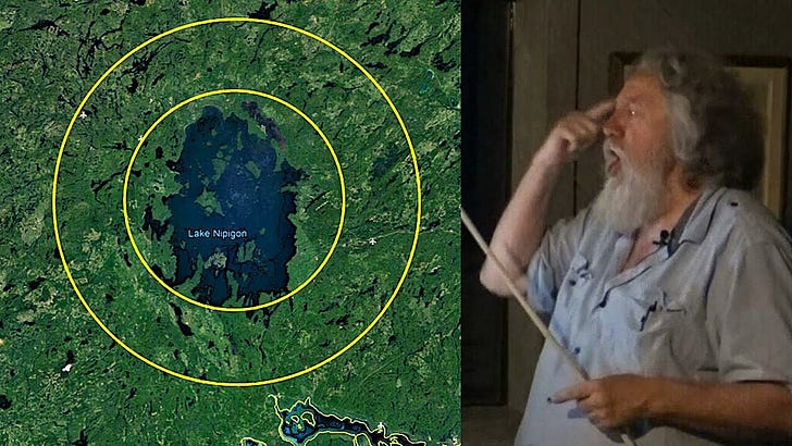
LAKE NIPIGON ICE AGE IMPACT
The video "Ice Age Impact at Nipigon Proposed - Ground Zero Analyzed with Randall Carlson" centers on the hypothesis that a comet or meteorite impact at Lake Nipigon, north of Lake Superior, played a role in ending the last Ice Age, specifically at the onset of the Younger Dryas period around 12,900 years ago {which I date to 4,500 years ago}. Randall Carlson discusses how this proposed impact could have caused rapid, catastrophic melting of the Pleistocene ice sheet, leading to massive floods that shaped the landscape, including the scoured basins of Lake Superior and other Great Lakes. The video highlights the unique bowl-shaped topography of Lake Nipigon and its raised rim, suggesting it may be an impact structure or at least a focal point for extraordinary glacial meltwater events1.
Key features and implications discussed include the extensive drumlin fields and deep lake basins in the region, which Carlson connects to the action of high-pressure subglacial meltwater floods rather than slow glacial recession. He challenges conventional explanations for the formation of these landforms and supports the Younger Dryas impact hypothesis, which posits that sudden extraterrestrial impacts triggered dramatic climate shifts, megafaunal extinctions, and cultural changes in early human populations.
Carlson explicitly notes that many drumlin fields in Canada appear to radiate from epicenters now occupied by extremely deep lakes, and he lists Great Bear Lake as one of these significant basins. He emphasizes that these lakes—including Great Bear Lake, Great Slave Lake, Lake Nipigon, and others—could mark the sites where impacts occurred, rapidly melting the ice sheet and triggering catastrophic floods.
DRUMLINS PINPOINT COMET IMPACTS
In the video, "Randall Carlson Explains How Drumlins Pinpoint the Comet Impact Events", Randall Carlson discusses the geomorphology of drumlin fields—elongated hills formed by glacial processes—and their significance in understanding past catastrophic events. He highlights specific locations such as western New York (notably near Rochester and the Finger Lakes), southern Wisconsin, and British Columbia. Using Google Earth, Carlson demonstrates how these drumlin fields are shaped like inverted boat hulls and are often found in radiating patterns that seem to converge on deep basins or former ice margins, such as those near Lake Ontario and the Finger Lakes region.
A key implication discussed is that these drumlin fields were likely formed by massive, pressurized subglacial floods rather than by slow, direct glacial movement. Carlson references the work of John Shaw, who proposed that such floods (which Randall thinks were possibly triggered by comet impacts over 10,000 years ago {which I date to 4,500 years ago}) caused the sudden end of the last ice age and led to catastrophic flooding across North America. This hypothesis challenges gradualist models of Earth history and suggests that evidence such as internal stratification within drumlins and abrupt changes in megafauna populations point to extraordinary, rapid events rather than slow, incremental processes.
LAKE ONTARIO IMPACT
In this video, "Ep053 Ontario Impact? New York Finger Lakes and Drumlins", Randall Carlson and the Kosmographia team focus on the remarkable glacial landscapes of upstate New York, especially the drumlin fields and the Finger Lakes region near Lake Ontario. They discuss the vast swarms of drumlins (elongated hills created by glacial processes) radiating around Lake Ontario and how the deep basin of the lake appears to be a focal point for these features. The Finger Lakes, with their long, narrow shapes and the dramatic glens and gorges feeding into them, are highlighted as evidence of sudden, catastrophic erosion rather than slow, gradual processes. The discussion also extends to drumlin fields beneath the Michigan lobe, southwest of Green Bay, Wisconsin. The episode raises questions about the timing and sequence of the formation of these flood features, suggesting that massive, rapid meltwater floods—possibly triggered by cosmic impacts—may have played a key role in shaping the landscape, challenging conventional gradualist interpretations.
DRUMLINS BY THE OCEAN
In this video, "Mega-scale Floods with Jerome Lesemann"2, Jerome Lesemann, a drumlin expert and student of John Shaw, joins Randall Carlson and the Kosmographia team to discuss the enigmatic features known as drumlins and their widespread presence beneath former continental ice sheets across North America. The conversation highlights the immense scale of drumlin fields and the staggering quantities of water required to form them, suggesting that their genesis is linked to massive, high-energy meltwater floods rather than slow glacial movement. This supports the controversial "Meltwater Hypothesis," which posits that catastrophic flooding events—potentially associated with the Younger Dryas Impact Hypothesis—played a crucial role in shaping these landscapes. The implications challenge traditional gradualist views, proposing that Earth's surface has been dramatically altered by sudden, extraordinary events in the recent geological past2.
The video discusses drumlin fields in a global context, highlighting not only classic North American locations like central New York and the Lake Ontario basin, but also the dramatic interaction between drumlins and the Atlantic Ocean in regions such as Nova Scotia and western Ireland. In Nova Scotia’s Yarmouth drumlin field, many drumlins extend into the Atlantic, forming islands that are actively eroded by waves and tides, exposing their internal structure and offering rare insights into their composition4,6. Similarly, Clew Bay in Ireland features hundreds of drumlin islands, the remnants of a drowned drumlin field, illustrating how rising post-glacial sea levels submerged low-lying landscapes and reshaped glacial features into archipelagos6.
These features imply that drumlin formation and preservation are closely tied to both catastrophic subglacial meltwater floods and subsequent sea-level changes. Evidence from erosional marks and drumlin exposure in coastal and submerged settings supports the hypothesis that massive, sudden meltwater events—not slow, gradual processes—played a critical role in shaping these landscapes1,6,8. The interaction with the Atlantic Ocean, through both erosion and inundation, not only reveals the internal composition of drumlins but also underscores the dynamic link between glacial processes and global sea-level fluctuations at the end of the last ice age.
MAPPING MELTWATER FLOWS
In this video, "Mapping Meltwater Flows"2, Randall Carlson explores the geomorphic evidence for massive meltwater flows at the end of the last ice age, focusing on several key locations. He discusses the Carolina Bays (mysterious elliptical depressions along the Atlantic coastal plain) and the search for Georgia tektites along the “fall line” south of Macon, Georgia. Carlson also references the Hiawatha Crater in Greenland and its possible connection to catastrophic flooding events at the ice sheet margins. The video highlights the suddenness of the Younger Dryas climate shift, the discovery of the carbon-rich "black mat" layer, and the need for an integrated theory that accounts for these extraordinary events.2.
The video discusses eskers as key evidence for catastrophic subglacial meltwater floods during the late stages of the last Ice Age. Randall Carlson highlights that eskers (long, winding ridges of sand and gravel) were formed by powerful, pressurized meltwater flows within tunnels beneath thick ice sheets. These features are cited as inconsistent with slow, marginal glacial melting and instead point to episodes of intense, rapid drainage, likely triggered by sudden climate shifts or even cosmic impact events. The presence, orientation, and sediment characteristics of eskers are used to reconstruct the pathways of ancient meltwater rivers and to argue for the scale and energy of the floods that shaped them.
The implications discussed in the video are significant for understanding Earth’s recent geological history. Eskers, along with drumlins and other flood features, support a model in which vast amounts of meltwater were released catastrophically, reshaping landscapes in a matter of weeks rather than millennia. This challenges traditional gradualist interpretations and aligns with evidence for abrupt climate transitions, such as the onset of the Younger Dryas. The video positions eskers as crucial markers of these high-energy events and as a window into the hidden dynamics of ancient ice sheets9.
MISSOULA FLOOD FROM BRITISH COLUMBIA
In this video, "Missoula Flood Glaciers and Ripples", Randall Carlson explores the dramatic glacial and flood-sculpted landscapes of Montana and British Columbia, focusing on the aftermath of the Missoula Floods at the end of the last Ice Age. Key locations include Flathead Lake, Camas Prairie, the Bitterroot Valley, and the area around Prince George, British Columbia. Carlson describes how catastrophic meltwater outflows scoured valleys, deposited vast layers of glacial silt, and created giant current ripples and outwash plains. He highlights the presence of thousands of drumlins near Prince George, which serve as indicators of massive subglacial water flows, and explains how the orientation of these drumlins reveals the direction of ancient flood currents. The video also discusses terminal moraines and spillways, showing how glacial lobes and meltwater channels shaped the modern landscape. The implications are significant: these features point to sudden, high-energy events, rather than slow, gradual processes, as the primary forces behind the region's geological evolution, supporting the idea that much of the northern landscape was rapidly transformed by megafloods and subglacial water flows at the close of the Pleistocene.
A friend of mine interpreted "matar" in the Bible associated with "fountains of the great deep" as meteors that were striking the oceans.
*volcanic
I am sorry, no Freud intended, the u was German, the v sat next to the c (and my eyes still in early morning mode on dwarfscreen).