NOAH'S ARK UPDATE
Noah's Ark, Remnant of Noah's Flood

CONTENTS — FIND IN PAGE
MY COMMENTS
NOAH’S ARK AS ADVANCED TECH
NOAH’S ARK UPDATE
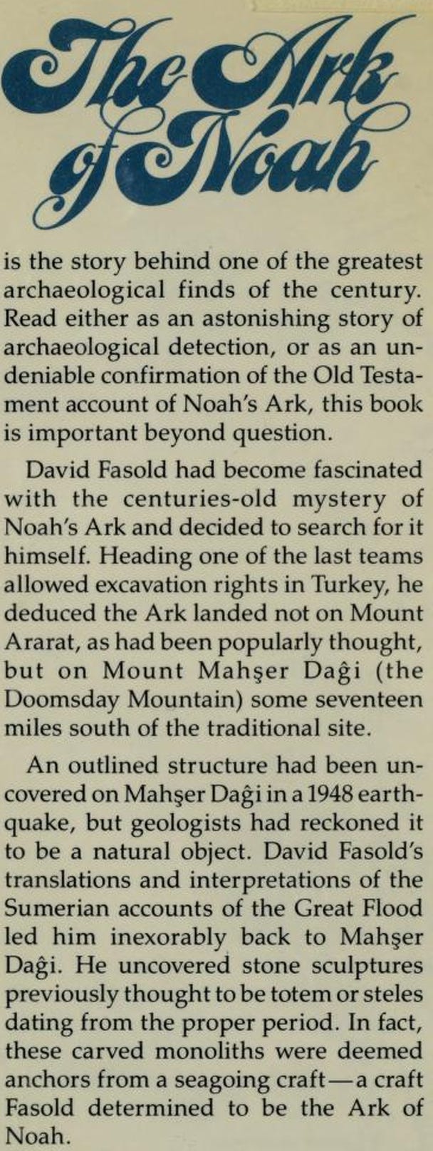
THE ARK OF NOAH, BY DAVID FASOLD
ARK ANCHOR STONES
ARK COVER
RON WYATT’S WORK
REBUTTAL TO CRITICISMS
ENOUGH ROOM ON THE ARK?
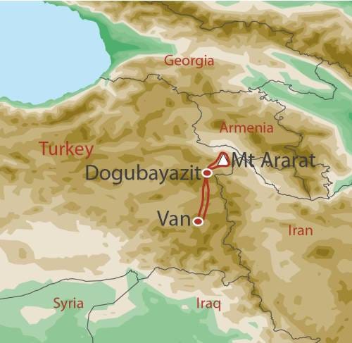
POSSIBLE NOAH’S ARK ROUTE DURING THE FLOOD
MY COMMENTS
Before Noah’s Flood, the present continents were likely still collected together in the supercontinent called Pangaea, which had no mountains. It was all relatively lowland. So it wasn’t difficult for tsunamis, caused by impacts and/or a close orbiting large body like the Moon on an elliptical orbit, to overwhelm and submerge all of the land, although it took several months, first of rain, then tsunamis, to do so. A large asteroid impact broke the continents apart rapidly and the impact shock caused mountains to form during the initial shock and again when the Americas overrode a pre-existing ocean ridge and when the India subcontinent slid under the Asian plate, raising the Himilayan Mountains, etc. So, in order for the Ark to land on a mountain, the Pangaea breakup had to occur before the end of the Flood, which the Bible seems to support.
Many trees were uprooted by the Flood, similar to the way the Mt. St. Helens slide flooded mountainsides by Spirit Lake and uprooted many trees, which formed a log mat on the lake for many years. Likewise, there were surely vast log mats after Noah’s Flood on which small animals may have survived. So the Ark may not have been needed to save all of them. There were apparently a lot of meteor strikes during the Flood, so it may have been difficult for the Ark to miss getting hit by one.
NOAH’S ARK AS ADVANCED TECH
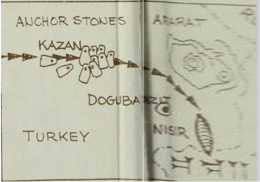
In this forum post https://www.thunderbolts.info/forum3/phpBB3/viewtopic.php?f=11&t=13&start=720#p8013 I said “huge drop stones with holes for ropes are found in a straight line for 8 miles approaching Mt. Ararat. They were likely used to keep the ark upright on wavy seas. A petrified bark is found which may have covered the ark.”
That comes from this video: youtube.com/watch?v=hRoQL7W5jg8.
This article https://creation.com/the-mystery-of-ancient-man explains why there must have been advanced civilization before and after the Great Flood. The ark was an example and the early megalithic structures after the Flood were too. Knowledge of such technology was lost over time, until some of it started to come back in recent centuries, but even now it’s doubtful that much of the technology known at that time can be equaled.
NOAH’S ARK UPDATE
Latest Discovery which could PROVE Noah’s Ark was real
https://noahsarkscans.substack.com/p/yes-we-truly-believe-this-is-noahs
Discovery Overview
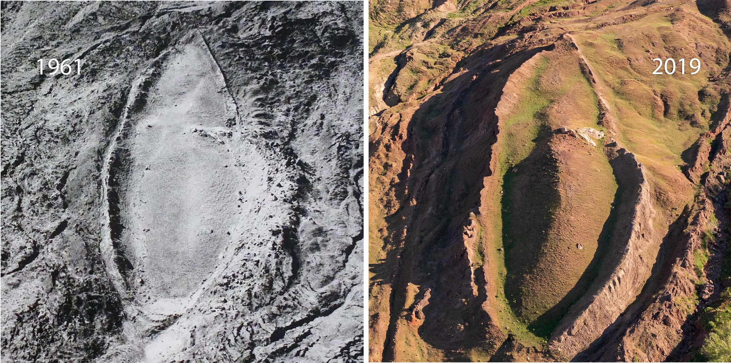
A researcher named Andrew Jones from Noah’s Ark Scans claims his investigations at a rock formation on Mount Ararat in Turkey could confirm the biblical Noah’s Ark as real. First spotted in 1959 at about 6,500 feet elevation, the boat-shaped rocks span 515 feet—aligning precisely with Genesis 6 dimensions using Egyptian cubits. Jones highlights new ground-penetrating radar (GPR) scans revealing underground “corridors,” tunnels along the edges, and a central cavity resembling an atrium, consistent with the Ark’s described three decks for animals and family.
Ground-Penetrating Radar and Structural Evidence
Recent investigations utilizing ground-penetrating radar (GPR) have produced striking results. Multiple scans from 2019 and 2023 reveal the presence of straight lines, right-angled walls, and hallways running along the structure. Some of these features extend up to 250 feet, suggesting the presence of internal chambers or corridors that resemble the decks and compartments described in biblical accounts. These formations are highly unusual for natural geological features, strongly hinting at possible human construction or modification. His team now plans robotic probes into the tunnels/chambers to explore further.
Soil Analysis and Organic Material
Soil samples collected in 2024 have provided additional compelling evidence. Laboratory analysis shows that the soil inside the formation contains nearly three times more organic matter and 38% higher potassium levels than the soil outside the structure, plus yellower grass—suggesting a decayed wooden vessel’s chemical signature after millennia. The increased organic content points to the decay of organic materials, likely ancient wood or biological remains, that have long decomposed over millennia. The soil within the site also exhibits higher acidity, which is characteristic of long-term organic decay, further supporting the idea of preserved organic material beneath the surface.
Geophysical and Structural Anomalies
Fossilized coral and seashells high on the mountain point to past flooding, per Jones. In addition to soil and radar data, other geophysical surveys such as LiDAR and electrical resistivity tomography (ERT) have detected layered and angled structures within the formation. These features do not align with typical natural geological formations, suggesting that the site may be a man-made or modified structure. The combination of these anomalies offers a strong case for further exploration into whether this is an ancient vessel or another type of constructed artifact.
Ongoing and Future Investigations
The research team, which includes Turkish and international scientists, plans to conduct further non-invasive surveys, core drilling, and possibly excavation. The primary goal is to gather more definitive evidence while ensuring the preservation of the site. The area faces natural erosion, which heightens the urgency of these investigations. The team emphasizes that initial work is focused on understanding the subsurface features without disturbing the site until sufficient evidence is collected.
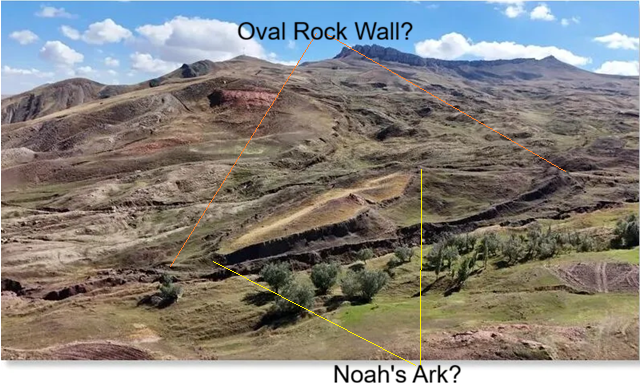
Above is a side view. Below is more of an aerial view.
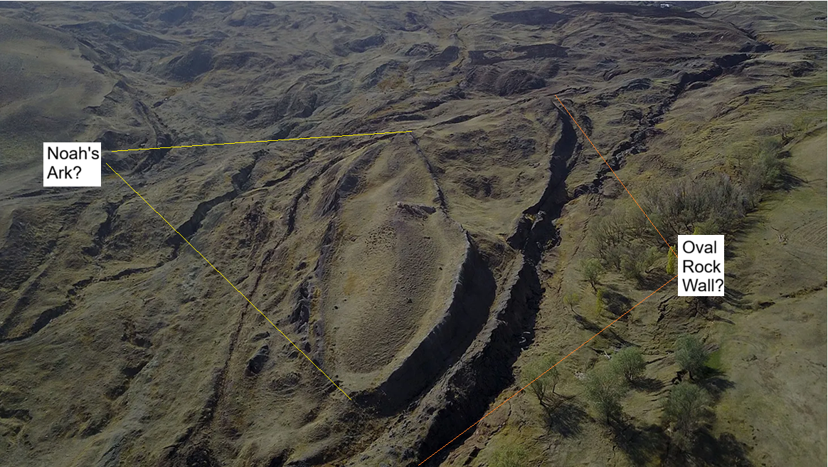
Since the oval-shaped rock wall must be rock, it’s plausible that the oval Noah’s Ark within the rock wall could also be normal rock, instead of remnants of the Ark. However, the details of items found within the Ark formation increase the odds that it’s actually the Ark. Ron Wyatt’s assertions were that the structure was a genuine ancient vessel, and he primarily attributed its preservation to the fact that it was buried in a mudflow, or volcanic ash, which protected it from erosion and decay over millennia.
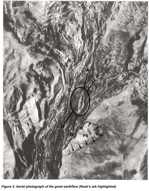
(https://noahsarkscans.com/articles/TelcekerEarthFlow-2007.pdf)
(worldexpeditions.com)
THE ARK OF NOAH, BY DAVID FASOLD
https://noahsarkscans.com/articles/The-Ark-of-Noah(David-Fasold).pdf
VIDEO: EXPLAINING NOAH’S FLOOD
https://www.youtube.com/watch?v=hRoQL7W5jg8
Evidence Supporting Noah’s Ark and Its Final Resting Place on Mount Ararat (54:45–57:53)
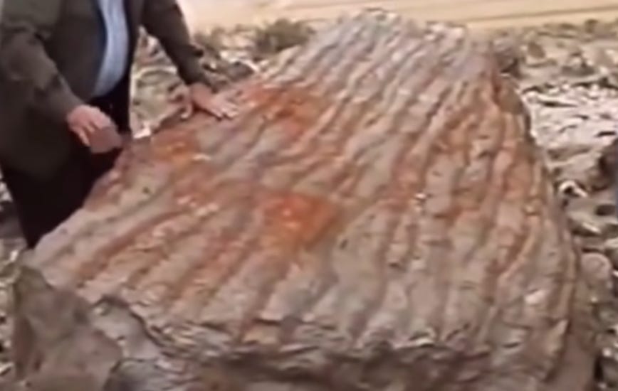
ARK ANCHOR STONES
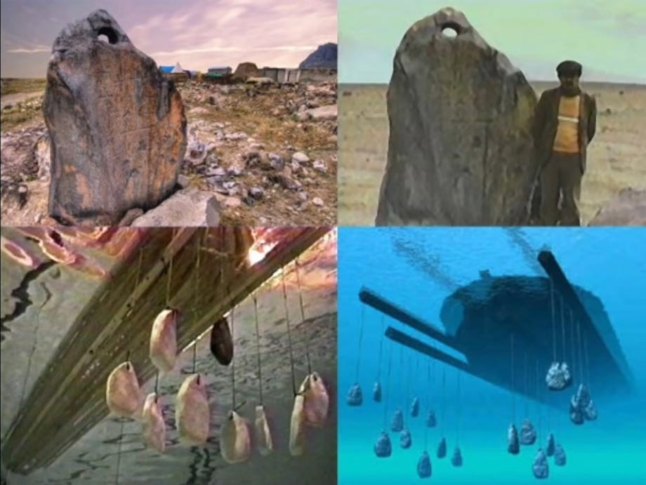
It is said that Noah’s Ark came to rest on the mountains of Ararat on the seventh month, the seventeenth day, and that there is now evidence to support this. Two remarkable discoveries have been made at the base of Mount Ararat: numerous large, drog stones scattered across the area. These gigantic stones appear as though they were dropped off from the ship itself, aligned almost in a straight line over eight miles approaching the mountains, as the water receded. These stones are thought to serve as a counterbalance for a ship during massive waves. The discovery prompted attempts to test whether a ship shaped like the Ark, weighing the same, could withstand huge tidal waves; the tests reportedly yielded perfect results, aligning exactly with what would be expected if the Ark was real. The results support the idea of Noah’s Ark being genuine. As the ship would roll and pitch in turbulent waters, the anchor stones would swing back and forth, similar to a shock absorber in a car, thereby slowing down momentum and providing a kind of stabilization. It is astonishing that Noah’s Ark might have employed such technology.
ARK COVER
The next significant discovery mentioned is a cover that Noah is said to have placed over the Ark. This cover is described as resembling bark and sounds like metal {due to fossilization}. Noah perhaps either removed or threw off this cover at some point. Overall, the narrative links these physical findings to the biblical account, emphasizing that the flood was a historically detailed event recognized by Jesus and the Apostle Peter, affirming Noah’s Ark and the Flood as real.
RON WYATT’S WORK
Ron Wyatt believed he located Noah’s Ark on Mount Ararat in eastern Turkey, specifically near the area called the Durupınar site, which he identified as the biblical resting place of the Ark. Wyatt conducted explorations in the late 1970s and into the 1980s. He reported that the structure was composed of petrified wood, with what appeared to be iron rivets, brackets, and anchor stones {in the area}, which he interpreted as remnants of the Ark. Wyatt asserted that volcanic activity and landslides had preserved these remains in situ, and he believed the site was the actual biblical Ark that survived the aftermath of the flood. He argued that the geological features around Mount Ararat supported the idea that the Ark had slid from a higher elevation during or after the flood. John Baumgardner, a notable geophysicist and researcher, collaborated with Wyatt on investigations related to the possible Noah’s Ark. Baumgardner was involved in analyzing some of Wyatt’s findings, including geophysical surveys and interpretations supporting the biblical account of the Ark’s location. Wyatt died in 1999 and his wife wrote the following rebuttal to critiques.
REBUTTAL TO CRITICISMS
This is paraphrasing Mary Wyatt’s article.
An article appeared in the Australian creationist magazine Ex-Nihilo that attempted to discredit the formation above as Noah’s Ark.
Claim of Multiple Boat-Shaped Formations
One of the primary claims against the validity of the Noah’s Ark site is that there are other boat-shaped formations in the area. Specifically, the article references a photograph from the 1950s, taken during a NATO survey of eastern Turkey, which purportedly shows three similar boat-shapes in the mudflow material near Lesser Mount Ararat. The response emphasizes that during the 1950s, the NATO surveys conducted high-altitude aerial photography covering every inch of this remote region, which was within 20 miles of a Soviet missile base. These photographs were primarily intended for military and strategic purposes, such as monitoring missile movements, not for geological analysis. When the photograph showing the “boat-like” shape was identified, experts like Dr. Arthur Brandenberger, a leading authority on stereo planography, confirmed that the object was indeed a ship. The careful examination of the photographs verified that no similar formations were overlooked, and any superficial resemblance to other shapes was dismissed after thorough investigation. Moreover, the photograph in question had been tampered with — touch-up work verified by the individual responsible — further casting doubt on the claim of multiple similar formations.
In addition, research by Ron Wyatt and his associates included a meticulous examination of other areas with superficial similarities. During broadcasts in August 1985, Dr. John Baumgardner, a geophysicist from Los Alamos National Laboratories, confirmed that the formation they were investigating was unique. He stated on national television that, although some formations might resemble the Ark, they lacked the specific characteristics found at the site they focused on, reinforcing the idea that this particular formation was distinctive.
Metal Readings and Their Pattern
The article claims that the metal readings obtained during investigations were random and not in a regular pattern, suggesting they lack significance. However, the same broadcasts and reports clarify that the readings were, in fact, organized and systematic. Dr. Baumgardner, during interviews, described how metal detectors confirmed the presence of metal at regular intervals, forming a pattern that was too organized to be coincidental. A report from the field expedition explicitly states that the pattern of metal detected was strikingly organized, reinforcing the idea that the formation contained man-made features, possibly structural components of a vessel.
The Molecular Frequency Generator
Critics have dismissed the molecular frequency generator used in investigations, likening it to a divining rod, and claiming it employs no scientific principles. However, independent researchers, including Terry Johnson of Tampa, Florida, have confirmed that the device operates on sound scientific principles. It functions as a frequency generator that detects resonances from metal objects underground by exciting their electron spin resonance. The process involves electromagnetic signals that are received back by the operator’s body, which acts as an antenna. This technology was invented by H. G. Heranimus, a government scientist, and is manufactured by reputable companies, costing around $6,500. The consistency of the results obtained with this device, aligning with other detection methods like ground-penetrating radar, underscores its legitimacy.
Radar Surveys and the Completeness of the Data
Claims that the radar scans were incomplete or unreliable are unfounded. The authors of the critique only had secondhand reports and no direct access to the extensive radar data collected over the years. In reality, radar permits from 1987 confirm that multiple scans of the site were conducted, covering various sections of the formation. These scans consistently indicated the presence of man-made structures beneath the surface, including layered formations and interior features that natural geology could not account for.
The Nature of the Deck Timber and Its Evidence
Speculation that the deck timber has not been verified is countered by detailed laboratory testing. Samples of the timber have undergone rigorous analysis at Teledyne-Allvac Labs, including tests for total carbon and electron microscopy examinations. These tests revealed the presence of organic carbon — proof that the material was once living matter — affirming it is not a natural rock. The organic content was measured at approximately 0.7%, and microscopic examinations confirmed the timber’s organic origin, consistent with construction timber from a vessel.
Artifacts and Their Provenance
Regarding alleged artifacts, such as the four-foot-long metal rods purportedly found by Turkish archaeologists, reports from reputable sources like John Baumgardner at Los Alamos confirm that Turkish authorities recovered metallic objects, including iron spikes and petrified wood, from the site. The claim that Ron Wyatt planted artifacts is refuted by multiple witnesses who observed the collection and documentation process firsthand, including the discovery of fossilized rivets, animal hairs, and antlers at the site.
The Fossilized Rivet and Its Composition
Critics argue that the fossilized rivet might be basalt, but laboratory analyses from Teledyne-Allvac demonstrate that the object contains significant organic carbon, which would not be present in basalt. The tests showed that the rivet had a much higher carbon content than surrounding rock, indicating it was once a living or once-living material — consistent with a metal or organic composite, not natural stone.
The Anchor Stones and Their Origins
Claims that the anchor stones are of Armenian origin and were altered over time lack supporting evidence. No credible photographs or reports show signs of earlier defacement or inscriptions. Tests with ultraviolet light and detailed examinations have failed to reveal any signs of prior carvings or modifications. The stones, made of basalt, exhibit crosses of Byzantine and Crusader styles, consistent with historical periods, but no evidence suggests they were planted or forged. The stones’ locations and inscriptions are documented, and no signs of tampering have been observed.
Manganese Nodule Claims
Some critics assert that ballast material is just manganese nodules from the ocean floor. However, laboratory analyses show manganese content of 84-87%, significantly higher than typical ocean-floor nodules, which usually contain about 35-50%. Additionally, the samples contain minimal copper, unlike oceanic nodules, which have higher copper levels. The size of the samples — up to 7 inches by 10 inches — also exceeds typical manganese nodule dimensions, further supporting their authenticity as anomalous artifacts, potentially linked to the site’s ancient structure.
Official Recognition by Turkey
Finally, claims that Turkey does not acknowledge the site are unfounded. Turkish newspapers like Hurriyet have published articles recognizing the site, and Turkish tourism literature promotes it as an archaeological and biblical site. Official plans for a visitor center and a highway to the area were disclosed in 1987, although political and terrorist issues delayed further development. Despite attacks by opponents, Turkish authorities have publicly acknowledged the significance of the site, and it remains a notable location within Turkey’s cultural heritage.
ENOUGH ROOM ON THE ARK?
Skeptics often raise common questions, such as, “What did Noah feed the animals on the ark? Where did they all go to the bathroom?” Clearly, these are significant concerns, but the answers are simpler than they seem. For example, in cold regions like Sweden, animals spend up to seven months each year indoors or under shelter to stay warm. To manage waste, people use a method called deep litter—spreading a thin layer of wood shavings, peat moss, and straw—which can absorb waste for up to two years without needing cleaning. This system also controls odors effectively. Its success relies on beneficial microbes that inhabit the litter; these microbes break down feces and eliminate harmful bacteria, leaving behind good bacteria. Regarding the animals’ diet, these would be small, young animals—necessary for repopulating the earth—and they wouldn’t require much food. Additionally, most animals can enter a hibernation-like state to survive extreme cold or famine. Many of the solutions and mechanisms discussed in this video are based on real, natural processes that could have been employed on the ark.
Wrong place. Wrong structure.
In Antiquity the original Mountains of Ararat were of Urartu (Aratta) south-west of Lake Van, the Mountains of Qurdii (Gordya as of Flavius Josephus,Judi as of Quran), modern Mt. Cudi in south-east Anatolya.
The tradition went from the South with the movement of the Armenians to the North to which was originally Mount Masi and renamed in the middle ages.