

HOW CONTINENTS DIVIDED
And How My Thinking Evolved

I thought it would be interesting to see how my thinking has evolved on the issue of Catastrophism, mainly for now on the subject of CONTINENTAL DRIFT, which the mainstream does not regard as a catastrophic event. So I’ll review a thread I started in January of 2009 on the Thunderbolts.info forum. I guess this is Part 1, since there are numerous pages in the thread that this post doesn’t include.
CONTENTS — FIND IN PAGE
IMPACT TO RAPID CONTINENTAL DRIFT — ELECTRICAL FORCES INVOLVEMENT — VS. HYDROPLATE THEORY — SUBMARINE CANYONS — SEAMOUNTS — HYDROPLATE THEORY DEEP CHAMBERS — DEEP CHAMBERS SEISMOLOGY — SOMALI BASIN & CONTINENTAL ROOTS — ELECTRICAL SCULPTING + VS. EXPANDING PLANETS — IMPACTS — VS. EXPANDING PLANETS — MEGAMASS FORMATION — PACIFIC & YUCATAN CRATERS — VS. SUBDUCTION — EMPTY ANCIENT OCEAN BASINS — VENUS HEAT & EARTH WARMTH — CONSENSUS — MEGALIGHTNING VS. IMPACTS
IMPACT TO RAPID CONTINENTAL DRIFT
Breakthrough on How Continents Divided
* A discussion of magnetic stripes on seafloors led me to do a search on that, which led to an amazing website about how the continents split up and moved apart. The site is http://www.newgeology.us and some excerpts follow. The theory is called Shock Dynamics. It doesn't connect with electrical dynamics, that I know of, but I think the latter is compatible with it.
* Large-scale evidence
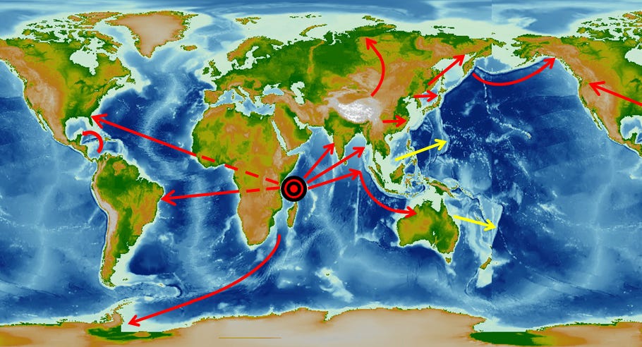
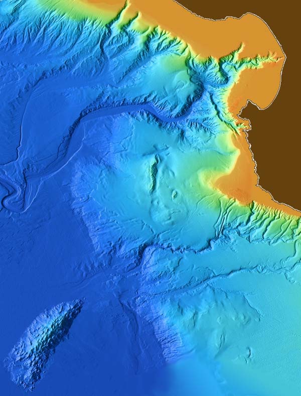
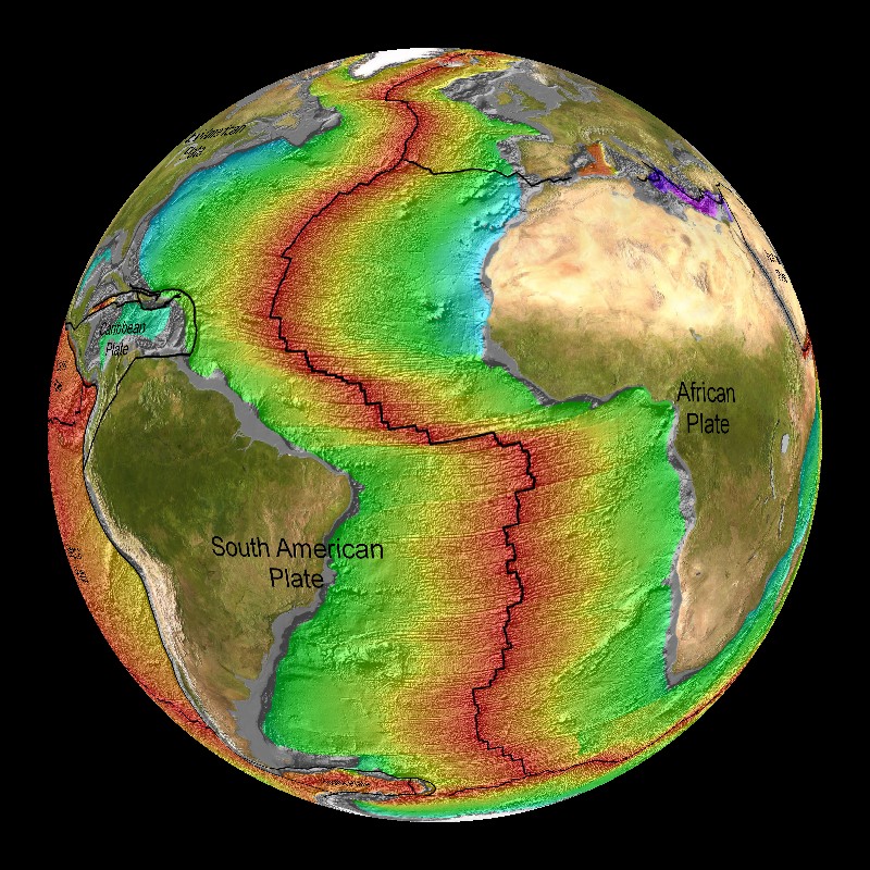
* 1. All continents that moved (North America, South America, Antarctica, Australia, India, Southeast Asia) went directly away from one unique central point (which was a crater). It is just north of Madagascar in the Western Somali Basin, centered on Wilkes Rise and the Aldabra Islands. (Australia was located there at the time. The circular shape of south Australia was the eastern side of the original crater. The crater was about 1,000 miles in diameter).
* experience with comparatively smaller events (though still large for humans) such as earthquakes, complex craters, and long-runout landslides suggests that a change occurs in the rheological properties of the crust at large scales of energy and mass. Continents slide smoothly as if on ice, while pressure and shear waves propagate unattenuated for thousands of miles. The apparent sudden freezing in place of these elements at the end of the event indicates a distinct threshold energy for such effects.
* What does this first-order evidence imply?
* To illustrate, if you hit a slab of ice hard enough with a big enough hammer, the ice shatters and the pieces slide away from the blow.
* That is precisely what happened to Earth.
* The meteorite impact was the hammer blow, and the continental crust was the slab of ice.
* Estimated time from start to finish:
Plate Tectonics - about 200 million years (and still ongoing)
Shock Dynamics - about 26 hours (based on a shear wave propagation speed of 150 m/s)
* a characteristic of the crust... Put simply, it temporarily acts like a fluid when enough stress is applied.
* Well known on a small scale as a Bingham Fluid, Melosh suggests that fluidization at the base of large landslides reduces friction to near zero. He calls it acoustic fluidization.
* That this turbulent feature (near the Aleutians) 'froze' in place is consistent with the apparent Bingham fluid (temporarily fluidizes under stress) nature of the crust.
* As with all accoustically fluidized crustal features in the Shock Dynamics model, once the fluidizing energy falls below a threshold level, the crust "freezes" {solidifies} in place.
* The fact that both Bowers Ridge and New Hebrides-Hunter Ridge (in presentation 13, next page) can be simulated with fluid turbulence is powerful support for the Shock Dynamics model, especially when compared to the flimsy Plate Tectonics explanations.
* This page http://www.newgeology.us/presentation41.html includes interesting info on radioactive dating.
ELECTRICAL FORCES INVOLVEMENT
Re: Breakthrough on How Continents Divided
* My suspicion is that the impact was electrical, although meteor impacts may be possible as well. If it was a meteor impact, my suspicion is that strong electrical activity accompanied it. Electrical forces may have a lot to do with making rock behave like ice, with low friction. The strike that hit next to east Africa I imagine was soon followed by many other electrical fireworks, like the many other large craters that formed, as well as the initial rifting of the Atlantic Ocean at what's now the mid-Atlantic ridge, the raising of mesas and massifs, and the electrical carving out of river valleys and sculpting of mountain ranges. The mountain ranges seem to have been raised up by the movements of the continents, but, when they were raised up, while still very hot, interplanetary lightning seems to have sculpted them to their present shapes, including those features and patterns that are only apparent at the larger scales, not visible except from a few hundreds miles altitude.
* I'm guessing this event is what killed off the dinosaurs a few thousand years ago.
VS. HYDROPLATE THEORY
Re: Breakthrough on How Continents Divided
* Hi Zane.
* I don't know how much time I'll have to discuss this, but I think the newgeology.us website really is a breakthrough on continental drift etc, even though it doesn't yet consider electrical forces much. I wrote to the site's author today about how EU theory is compatible with most of their findings, so maybe they'll reply. The site was put up though in 2005, so I don't know if that's likely.
* I think there's a lot wrong with the Hydroplate theory, mainly the water chambers under the continents. I don't think any such chambers have been detected. Most earth rock seems to contain water though, except for the continents, or the cratons within continents.
* I think it's unlikely that the Atlantic opened up the way Hydroplate theory suggests. The Shock Dynamics theory seems to explain that pretty thoroughly. The shock from the impact was transferred through Africa and Europe to the Americas, which split the Americas off and gave them motion, like hitting one croquet ball with another. The first ball stays in place, but the second one shoots off. Their analogy of hitting a slab of ice with a sledge hammer helps clear it up too. That ought to make a pretty simple experiment. Make a piece of ice an inch thick and a foot square and hit it with a hammer and see if we get any piece that stays put, while most parts shoot off.
SUBMARINE CANYONS
When the Ocean Basins were Empty?
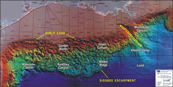
* I have a bunch of links here to images of submarine canyons etc. Canyons carved by water can't form under water and I doubt if they can form electrically under water either. That means there was little, if any, water in the oceans when the canyons formed. Some of them appear to have formed electrically. Maybe they all did.
{I now think it was possible for canyons to form underwater during Great Floods, when there was a lot of sediment suspended in the fast flowing water and there was soft sediments along continental shelves that would allow gulleys/canyons to form. However, as the Atlantic and Indian Ocean basins opened up during rapid continental drift, those basins were probably dry for a few hours till surrounding ocean water had time to arrive. Also, the Pacific waters would have been high at first and fell rapidly as the Atlantic and Indian Oceans were filling.}
California ? shelf canyons

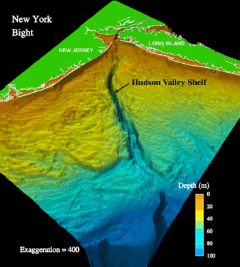
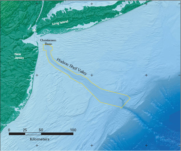
Hudson valley shelf canyon
http://clasticdetritus.files.wordpress.com/2007/12/sss_5d.jpg
Mississippi River shelf canyon
http://oceanexplorer.noaa.gov
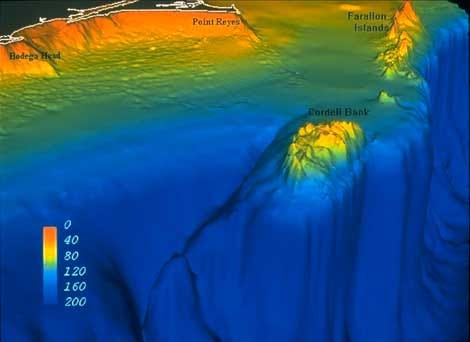
Farallon Islands & Cordell Bank vertical shelf cliff http://cordellbank.noaa.gov
Puerto Rican trench http://woodshole.er.usgs.gov
Sumatra shelf https://sites.google.com/tamu.edu/ocean-world/
Fraser Island, Australia shelf http://clasticdetritus.files.wordpress.com
Seafloor River {in N. Pacific} {& farther south} http://www.ifremer.fr
shelf canyon http://elkit.blogs.com, http://faculty.gg.uwyo.edu, http://clasticdetritus.files.wordpress.com
Hawaii seamount canyons http://www.drgeorgepc.com/tsuHawaiiPapauSeamount.gif
Lamont fulgamite seamounts http://ocean-ridge.ldeo.columbia.edu
Seamounts
* This link should take you to the site's discussions of seamounts:
http://www.google.com/search?hl=en&q=si ... h&aq=f&oq=
* I hadn't heard that seamounts are the same height. I don't think they are. It seems they formed before the ocean basins filled with water. Some are apparently volcanoes, but other seamounts appear to have been formed electrically, like Olympus Mons on Mars. They even have very similar looking craters, especially some off the coast of Oregon.
{I now think many of them are the same height due to erosion above the ocean surface.}
HYDROPLATE THEORY DEEP CHAMBERS
Re: Breakthrough on How Continents Divided
Lloyd wrote:* * I think there's a lot wrong with the Hydroplate theory, mainly the water chambers under the continents. I don't think any such chambers have been detected. Most earth rock seems to contain water though, except for the continents, or the cratons within continents.
There would not be the large chambers in the aftermath of that event but many very deep water chambers have been found even so. Two instinces were found at two of the deepest drill holes in the world, one on the Kola Peninsula in northern Russia at 7.5 miles deep and the other in Germany's northeastern Bavaria at 5.6 miles deep. In Russia's drill hole, hot salty water was flowing through crushed granite. In the German's, cracks were found through-out the lower few miles. All contained sea water in concentration about twice that of sea water. (from page 94 of hydroplate theory material). . And there is more but i'll need to find the references again for those details, but I cannot imagine there not being watered trapped. d...z
DEEP CHAMBERS SEISMOLOGY
Re: Breakthrough on How Continents Divided
dahlenaz wrote:
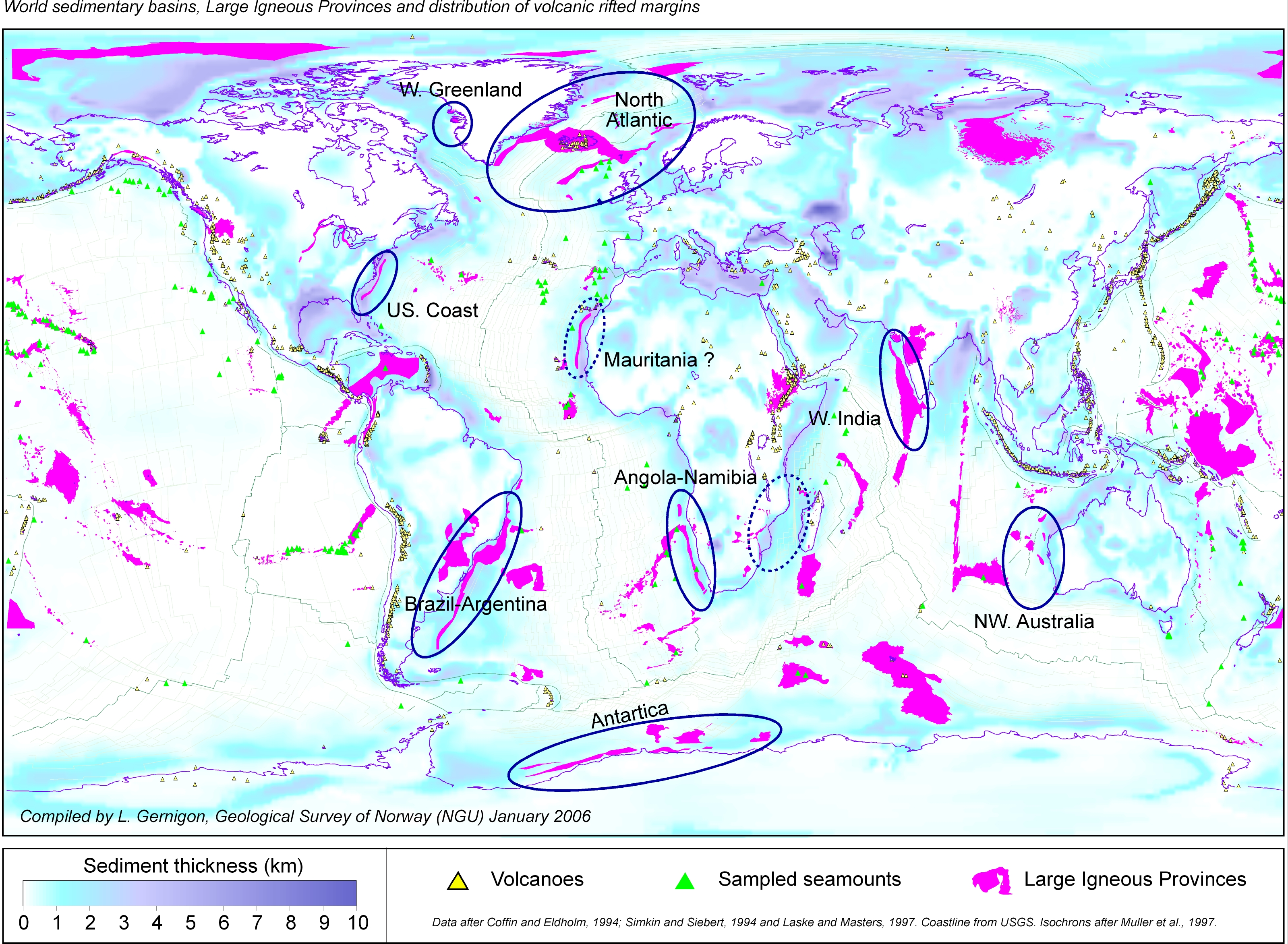
There is one big problem with the location this theory points to as the epicenter. You can see in the map at this link the absence of an igneous concentration at this location. http://en.wikipedia.org/wiki {Somali Basin}
d, I wouldn't necessarily take that Wiki entry for gospel. Notice that all their igneous provinces are surface exposed.
Working in the same industry as seismologists, i've gathered that, below certain depths or behind some intervening geologic strata, acoustics cannot reliably identify the nature of a reflected signal; ie: could be igneous, could be water, could be salt, or etc.
Overall, the Shock Dynamics impact scenario is highly intriguing, though like a number of theories around, they perhaps try to explain too much and then fall back on incongruous traditional theory, when stumped.
I like their "pivoting" ideas and their "relative 'eastward' mantle flow" conclusions, but they might could benefit their 'seafloor spreading' analysis by combining it with the fluid dynamics "focused porous flow" process detailed in the SCIAM article (cited in http://www.thunderbolts.info/wp/forum/phpB ... 013#p17013 Jan 25.
SOMALI BASIN & CONTINENTAL ROOTS
Re: Breakthrough on How Continents Divided
* Zane, here's a world map of Igneous formations:

Notice that the Yucatan crater and Hudson Bay craters etc also show no igneous material.
* On this Shock Dynamics webpage http://www.newgeology.us/presentation6.html the first image shows an arc of volcanic islands on the southern edge of the Somali Basin crater. Wouldn't those be igneous enough?
* Have you read this page on the Antipodal http://www.newgeology.us/presentation35.html effects, i.e. the Superswell in the Pacific Ocean?
* As for Iceland, why do you suspect it is an impact site?
* This webpage http://www.newgeology.us/presentation20.html says the mid Atlantic ridge is under compression, i.e. the adjoining plates are pushing toward each other, rather than pulling apart. That contradicts the Hydroplate theory and supports Shock Dynamics. Here's what it says.
In Iceland, the largest landmass astride the Mid-Atlantic Ridge, the predominant stresses in the axial zone are likewise compressive rather than extensional (Keith, 1993). Earthquake data compiled by Zoback et al. (1989) provide further evidence that ocean ridges are characterized by widespread compression, whereas recorded tensional earthquake activity associated with these ridges is rarer. The rough topography and strong tectonic deformation of much of the ocean ridges, especially in the Atlantic and Indian Oceans, suggest that, instead of being "spreading centers," they are a type of foldbelt (Storetvedt, 1997).
* At the bottom of the page it says: The existence of deep continental roots ... untenable.
* The Hydroplate theory supposes there was a layer of horizontal chambers full of water about ten miles below the surface, as I recall. The continental roots, or cratons, are much deeper than that, as much as 150 miles or so. So the continents would not have slid on a layer ten miles deep, but much deeper. The Shock Dynamics theory says they were formed by stresses and heating from the impact, but it seems that they would make it difficult for the continents to slide. But if we compare the continents to slabs of ice that are thick in places, I suppose such ice slabs would not be greatly hampered in moving over a liquid body. Electrical forces may have helped reduce the friction and may have heated the lithosphere and made it less viscous.
* I'd be interested in hearing how large the water chambers were that were discovered by the Russian and German drillers. I forget how deep the Hydroplate theory supposes they were internally.
{I later learned that the continental roots, according to NewGeology.us, formed immediately after the continents slid to their present positions over the much shallower plasma Moho layer.}
ELECTRICAL SCULPTING + VS. EXPANDING PLANETS
Re: Breakthrough on How Continents Divided
* Zane, did you see this page: http://www.newgeology.us/presentation16.html? They seem to account for the Ural Mountains with the Somali Basin impact. There's a video which shows it well at the top of that page. They say the Australia-India section of Pangea or whatever was forced northeast, it seems, then India hit Asia and built up the Himalayas, while Australia broke off from India and ricocheted ESE. Asia pivoted at Iran, which caused it to move north first, then west. The westward motion caused the Urals to fold up.
* There were obviously lots of "impacts" besides the Somali Basin one, but it seems that was the first one and the biggest one. {No, I later found from Michael Oard’s writings that there were many impacts before the point during the Flood that the continents broke apart.} From EU theory we know that electrical impacts are what probably form tektites and they show a picture of a large area of tektites apparently from the impact site all the way to Australia. {I now think the impact momentum & heat produced the tektites, though electrical forces were involved in the heating etc.}
* They say the continents took 26 hours to break apart and run their whole courses on a wave of magma moving 150 meters/second to nearly their present positions. My impression is that 90% of all of the electrically formed features on Earth were formed in those 26 hours. That includes the sculpting of mountain ranges and the Grand Canyon, the formation of cratons, mesas, massifs, seamounts etc, impacts like at Yucatan, etc. They seem to say that the Hudson Bay craters and some others existed before the Somali Basin impact.
* I"m not biased against other theories, but this one, Shock Dynamics, seems to explain more things about the continents and sea floors better than any other. I think EU theory will improve it quite a bit. Hydroplate theory seems to be similar only with respect to the idea that the continents slid to their present positions, but it says water was what they slid on, whereas Shock Dynamics says it was a magma wave. Water may be an important ingredient in magma, which may make it slicker than waterless rock. But I think electrical plasma properties likely contributed a lot to the reduced friction that allowed the continents to slide. The site mentions that landslides from continental shelf cliffs tend to slide much further on the sea floor than the height of their falls. This could also involve electrical effects. Piezoelectricity I think is mentioned on the site, but I don't remember if it's considered as a possible "lubricant".
* I previously thought a combination of expanding planet theory and EU theory would best explain the continents and seafloors, but now Shock Dynamics impresses me much more. I don't know if expanding planet theory is needed any longer. At least it doesn't seem needed to explain how well the continents fit together or what caused the Atlantic etc to open up. Expanding Planet theory would suggest that the Atlantic should be the same width all the way from the Arctic to the Antarctic, whereas Shock Dynamics seems to explain elegantly that the reason the Atlantic is much wider toward the south is because South America received more of the energy of the impact than did North America. I know Expanding Planet theory says the continents would fit together on a smaller globe and fill in the entire Pacific Ocean as well as the Atlantic and the others, but I'll have to look at those pictures again to see if they're still convincing, if I get time.
* Okay, I just looked at Neal Adams video at https://oilismastery.blogspot.com/2008/10/expanding-earth-outline.html and it's pretty impressive, but I think he makes the continents rather plastic in order to make them fit together on the Pacific side. I don't think they'd fit if they were more rigid. What say?
IMPACTS
Re: Breakthrough on How Continents Divided
I'm with you on shock dynamics. Good seismic and tectonic evidence to support it. The expanding earth concept offers no reasonable explanation for ocean water or for the systematic distribution of mountain ranges, whereas shock based continental drift has several strengths, including the recognition of meteoric impacts/electric strikes as a major mechanism for planetary formation. I would add the proposition, as I mentioned elsewhere a long time ago, that the Pacific Basin itself is [possibly] a classic hexagonal crater; also the Gulf of Mexico is a prime candidate for continental-drift-starting impact(s) including the important Chixilub crater on its southern "rim."
VS. EXPANDING PLANETS
Re: Breakthrough on How Continents Divided
I've seen and enjoyed the remarkable expanding earth videos, and read and commented on Neal Adams theory elsewhere...
here's my beef:
First of all this video answers neither of objections I stated above.
In addition, Adams' physics and math are screwed up. The ocean floor, comprising nearly 3/4 of the surface area of the planet, though thinner, is made of heavier rock [predominantly basalt] than the continents [mostly granitic]. Adams does not account for the denser aesthenosphere and mantle rock beneath the crust which, because of the same isostasy he depicts in the video, is going to be slightly more concentrated toward the "oceanic side" of the Pangaea earth. This, plus the heavier oceanic crust nicely counterbalance the lighter floating continental masses on the opposite side. Even if the barycenter of the earth is shifted somehow, which I disagree with Adams' depiction of same, there is no proof that this would disable the continental drift theory. I am reasonably content [though not absolutely] with "subduction", the seismic evidence is very good and clear. But silt deposits in subduction zones are a straw man... why would there be significant deposits if the material there is subducting? It would just be conveyed/incorporated into the lower aesthenosphere and mantle. The evidence is good for continental drift and seafloor spreading... there is no indication of major size inflation of the earth, certainly not enough to support the radical expansion required to affirm Adams videos... and no credible explanation for the arrival of oceans of water from who knows where during the process... the gravitational anomalies mentioned elsewhere as regarding the size of prehistoric animals are poorly founded, but even if possible, still do not correspond to the huge inflation needed by the expanding earth hypothesis. Finally, this video depicts Adams' assumption that the continents were centered on the equator. {I think the continents were close to the equator before rapid continental drift spread them out more.} There is no reason for this whatsoever. Climate worldwide was tropical/subtropical during most of "prehistory", with good support that this was due to the lower albedo of a greenhouse type atmosphere. Because of this, the early earth's warm climate conditions left fossilized worldwide need not be attributed to equatorial placement. For the reasons I stated above, this is not a problem anyway.
MEGAMASS FORMATION
Re: Breakthrough on How Continents Divided
seasmith said: So now do you think that Earth is done growing, or, as per the view of the David Pratt paper...
{The following was my former view on galaxy, star and planet formation, but in 2012 or so, I was persuaded to Charles Chandler’s view, which finds that static electricity likely forms interstellar filaments which soon implode to form massive bodies.} * TB plasma cosmology theory says the Earth, like Venus and other bodies, formed by ejection from Saturn, or possibly Jupiter etc. I think it's a different electrical process from how stars and galaxies form from plasma guns. Galaxies form from quasars and quasars form in the nuclei of active galaxies where the plasma guns exist. Quasars start out nearly massless, highly ionized, and with very high velocity, then gain mass and lose velocity. Stars form apparently in planetary nebulae in a similar way to quasars. So stars probably start out small, nearly massless, and at high velocity probably with high ionization. TB theory says they form in galaxy-scale z-pinches. But, just as quasars can form as several smaller bodies, rather than single larger quasars, and these smaller bodies become small galaxies, stars may sometimes form into several smaller bodies as well, such as planets, maybe gas giants.
* If gas giants can produce solid planets in a way similar to how stars and galaxies form, then it seems likely that these solid planets would start out small and massless and grow to a maximum size. Galaxies and stars don't seem to keep growing forever, but reach a maximum and then maintain the same mass and volume thereafter indefinitely. If our local planets and moons started out in this way, then it seems likely that they have largely reached their maximum growth, because none seem highly ionized compared to their parent, Saturn. Quasars gain mass apparently by Marklund convection, which is like lightning, which scours the local space of much of its matter concentrating it all at a center, i.e. in the body of the quasar. This seems to be how stars gain mass too. So perhaps it's also how planets gain mass (and volume).
* I didn't read a lot of the David Pratt paper. The part you quoted doesn't seem to be part of the Shock Dynamics theory. Pratt's material was used as evidence against conventional plate tectonics.
PACIFIC & YUCATAN CRATERS
webolife said: the Pacific Basin itself is [possibly] a classic hexagonal crater; also the Gulf of Mexico is a prime candidate for continental-drift-starting impact(s)
* Re the Pacific Basin, I've also theorized that the continents are fulgamites, which are raised electrically like mesas and like Olympus Mons on Mars. That would mean the seafloors are what was not raised up. It may be that only the cratons within continents are fulgamites, rather than the whole continents. Anyway, I think we'll have more definite answers within a few years.
* Re the Yucatan impact as a spreading center, I guess the Shock Dynamics video doesn't show that, does it? I forget. {NewGeology.us later concluded that the Yucatan Chicxulub crater area was initially atop what is now Cape Verde Islands near Africa. The Somali Basin impact occurred immediately after and caused the upper crust at Yucatan to slide away over what is now the Atlantic seafloor, where the Cape Verde Islands formed from the impact there. It’s like shooting a hole through 2 layers of paper and then sliding the top or front layer off to one side. The same apparently happened at Iceland and the Hudson Bay.}
VS. SUBDUCTION
allynh said: Pangea as a starting point doesn't work and any discussion of subduction has to explain why there is no mountain of muck and silt along the subduction zone
* Re why you can't start with Pangea, did you see the Shock Dynamics video, which showed how the Somali Basin impact would have started with a supercontinent?
* Re subduction zones, Shock Dynamics doesn't need or accept subduction as the cause of seafloor spreading.
* webolife last said: 1. I am reasonably content [though not absolutely] with "subduction", the seismic evidence is very good and clear. and 2. there is no indication of major size inflation of the earth and 3. and no credible explanation for the arrival of oceans of water from who knows where during the process and 4. Climate worldwide was tropical/subtropical during most of "prehistory", with good support that this was due to the lower albedo of a greenhouse type atmosphere.
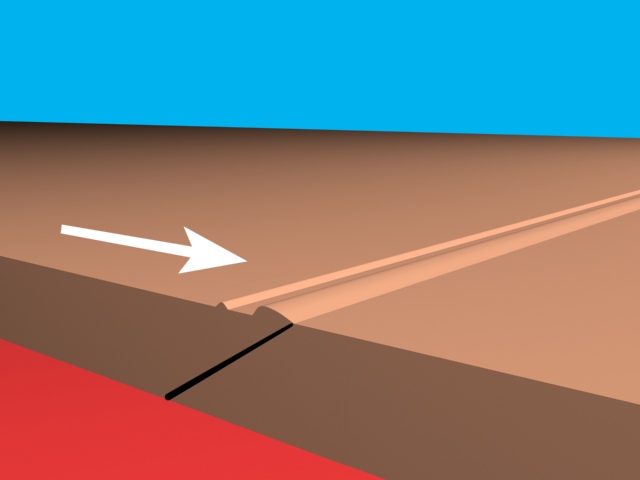
* 1. This seems to cover everything said about subduction on the newgeology.us site: http://www.google.com/search. But this page http://www.newgeology.us/presentation10.html seems to explain the matter better with images including this one http://www.newgeology.us/WavStop.jpg and this quote: A crustal wave (red line) from the low angle impact was launched in the direction of travel of the meteorite, and "froze" in the end to form an inclined trench. In other words, the trenches or "subduction zones" are a result of the continents' motions and not the cause of their motions.
* 2. I'm not very sure yet about expansion.
EMPTY ANCIENT OCEAN BASINS
* 3. Apparently you don't know Talbott and TB friends' theory, based on mythology, plasma cosmology and some geology, that most of the water of the present oceans was held in the plasma column that extended from Earth's north pole to Saturn until the Saturn configuration was disrupted about 5 thousand years ago by Jupiter. So the ocean basins were largely empty until then, which was the time of the Great Flood. This is evidenced by the canyons on the continental shelves and some seamounts, which extend from the shelves all the way to the seafloor. These canyons were probably carved by electrical discharges, but, even if they were formed by flowing water, we know that probably neither flowing water nor megalightning can form canyons under water. Thus, the ocean basins were largely empty. {I explained above that I now consider this less likely. The ocean waters were needed to flood the continents and deposit the sediments on them that are there now.}
VENUS HEAT & EARTH WARMTH
* 4. The idea of a greenhouse atmosphere comes from the discovery in the 60s I think that Venus is extremely hot, like over 700 degrees F, whereas scientists at the time expected it to be cold, because the thick atmosphere should prevent sunlight from penetrating very far. As usual, they jumped to the wrong conclusion. They didn't consider the possibility that Venus is a young planet, which has not yet cooled down from its initial molten state. They ignored Velikovsky's prior claim that Venus was incandescent in historical times and was a new-born planet, though he thought it was born from Jupiter. The reason Earth's entire climate was warm up to about 5 thousand years ago is because Earth was in the protected extended atmosphere of Saturn, which was a brown dwarf star. So the climates of Mars and Saturn's moons and our Moon, which probably came from Saturn, were also warm at that time. So says TB theory. Last edited by Lloyd on Thu Jan 29, 2009 9:48 pm, edited 1 time in total. {It still seems certain that Venus heat did not come from greenhouse heating of its atmosphere, since the clouds block solar radiation. Instead, former cataclysmic events likely heated it. Ancient myths still seem to call for Earth formerly following Saturn, Venus and Mars on a highly elliptical orbit or a distant trajectory, but I need to re-evaluate that evidence.}
CONSENSUS
Re: Breakthrough on How Continents Divided
Post by Lloyd » Fri Jan 30, 2009 7:38 pm
How's this for a summary of the supercontinent breakup?
*NG: All the continental land masses were originally a single supercontinent.
* Then a large meteorite struck the Somali Basin, which shattered the supercontinent into several pieces.
*LK: This occurred 5,000 years ago. The impact was either electrical discharge, or both a meteorite and electrical discharge. {Now I say impact momentum.}
* The impact occurred during the breakup of the Saturn System. {No, it occurred centuries during the Great Flood, unless that’s when the Saturn System broke up. But I think it broke up during the Younger Dryas cataclysms.}
*NG: The pieces all moved away from the impact site, building small mountains first on the sides of continents nearest the impact, and lastly mountains on the far sides of the continents due to return of friction as they slowed down below a threshold level.
*LK: The bottoms of the continents were made frictionless, like ice, due to electrical heating and impact stresses. {The Moho layer is frictionless plasma.}
*DZ: A second strike occurred at Iceland, which helped split off the Americas.
*WL: Chicxulub impact occurred on Yucatan, splitting off the West Indies.
*NG: Tektites fell in the area from the impact site to Australia.
*LK: The ocean basins had very little water, so canyons were carved into the sides of the continents and on their top surfaces by electrical discharge machining. {No, the oceans were likely about the same level as today.}
*NG: The trenches, or subduction zones, were formed as the continents ended their runs.
*LK: The dinosaurs etc were killed during this cataclysm. {No, probably a little earlier during the max Flood level.}
* The Great Flood occurred shortly after when the continents broke up and had finished their runs. {No, the Flood likely occurred first, because the sediments were already deposited before the continents separated.}
*SS: What little sediments are on the seafloors were mostly formed electrically. {No, seafloor sediments formed mostly from erosion runoff.}
* I'm not convinced of DZ's and WL's impact theories at Iceland and Yucatan, but they're plausible for now. I'd like to see evidence of a major impact at Iceland. {Now, it seems that Iceland itself is the evidence. The meteorite/asteroid went deep, helping split the supercontinent and magma was forced upward, forming Iceland.}
MEGALIGHTNING VS. IMPACTS
Re: Breakthrough on How Continents Divided
* Re Steve's statement that large bodies probably never strike the Earth, I've been saying that too, but, since it seems possible for a large body to strike the Earth under special circumstances, I don't think it should be ruled out. When I said impact above, I meant either the impact of lightning or meteorite and lightning.
* One question is what would be the special circumstances and another question is could the supercontinent have shattered with only a megalightning strike and not the extra mass and momentum of a large meteorite(?).
* The circumstances under which a large body could strike the Earth I think would be 1. if both bodies were uncharged, and 2. if they were charged the same in the right proportion.
* I think 2 bodies of the same size that had the same charge would behave like neutral bodies, whereas if 2 bodies had the same charge but were of different sizes there would be a discharge. Does anyone know if that's true or not? By size, I don't know if volume or mass is meant, but I think volume. I think Juergens said a soap bubble and an iron sphere of the same diameter would hold the same charge, if connected by a wire.
* As to whether a megalightning strike could cause a supercontinent to shatter and cause the pieces to fly apart in all directions, that's farther beyond my understanding so far. I read about lightning splitting huge boulders and throwing large parts for a few hundred feet or yards. I also just read that lightning can have 300 million amps and a billion volts and that recent lightning on Saturn was ten thousand times more powerful than Earthly lightning. {Charles Chandler later persuaded me that a lot of mass would be needed to have much effect, and megalightning would have way too little mass & charge.}
Impacts vs. EDM
* I overlooked this a little earlier from Steve:
First, and most important, electricity is a "pull" phenomenon. Rather than impact from an ion beam causing explosive or evaporative effects, it is the return stroke back to the leader that causes most of the shock dynamics. Craters were not punched into the Earth, the missing material was yanked out of it.
... In my view, the ocean bottoms were excavated by whatever object (or cloud of electrified plasma) approached Earth closely enough to initiate the upward discharges. The mid-ocean ridge is a classic example of the narrow center channel, uplifted into a dual-ridge structure, surrounded by a wide, flat-floored canyon. In this case the "canyon" is the width of the ocean basins.
All one has to do is spend the time reviewing the forms on the bottom of the ocean and notice that the mid-ocean ridge is highlighted by perpendicular "cracks" along its entire length. They were formed when the ions to the sides of the primary trackway were pulled into its outflow upward to space. The periodic nature of the transverse "cracks" is one clue to their formation.
* It's plausible that electricity may be generally a pulling or attractive force, but does it also necessarily pulverize everything it pulls off of a planet? The Face on Mars is one among a large number of large rocks pulled apparently from Valles Marineris, which fell back down to the surface. Juergens thought it likely that Mars encountered the Moon in ancient times and one body acted as a cathode and the other as an anode. Isn't that possible? The discharge goes from one body to the other; does it not? So, if material is pulled from one, it's pulled onto the other. Right? And doesn't the material then impact the other body?
* We know meteorites strike the Earth, but I don't know that they impact it with much force. I know they sometimes damage buildings etc. But I don't think I've heard of any making deep impacts. The largest meteorite is said to be about 60 tons, which I suppose would be about 400 to 600 cubic feet, the size of a car or small truck. Meteorites apparently come from meteor streams. TPODs said the Tunguska explosion probably involved a meteor from the Taurid stream, which is the stream Comet Encke follows. Apparently this meteor came within a close distance of impacting the Earth before it exploded electrically. The blast knocked down trees over a wide area. A blast is not an attractive or pulling force. Isn't it possible for a larger meteor to impact Earth, if going fast enough?
* I can't accept the idea that the Atlantic seafloor was all carved out electrically, until a few seeming contradictions are cleared up.
* First, Comparing the Atlantic Ocean and Mars' Valles Marineris, see the following links.
Full-length view of Valles Marineris:
http://astrogeology.usgs.gov/Projects/M ... ineris.jpg
Full-length view of Atlantic seafloor:
http://sos.noaa.gov/images/Land/sea_floor_age.jpg
Large view of VM from the center to the West:
http://www.imagico.de/pov/pict/mars04.jpg
Whole Earth view:
http://upload.wikimedia.org/wikipedia/c ... vation.jpg
* Here is a comparison of features.
* Atlantic Ocean is over 10,000 mi long from Spitsbergen to Antarctica, from 1770 to 4000 mi wide, and about 2 mi deep.
Oriented north-south, it's very S-shape curved and connects with northern and southern oceans.
The mid-Atlantic ridge is over 8,000 mi long or 4/5ths the length of the ocean.
The ridge has a central rift along the entire length; ridge and rift are offset by numerous transverse faults.
Opposite shores of the ocean match up like puzzle pieces.
The rock types of opposite shores also match up well, according to Cardona.
* Valles Marineris is over 2400 mi long, from 40 to 150 mi wide average, with 435 mile width near the center, and from 4 to 7 mi deep.
The canyon is oriented east-west, is nearly straight, barely slightly sin-wave-shaped and connects with the northern basin; see http://web.pdx.edu/~ruzickaa/G456/Mars1lab/Mars1.htm .
The mid-canyon ridge in Valles Marineris is nearly straight, is about 500 mi long or 1/5th the length of the canyon.
The ridge has no apparent central rift and there are no apparent transverse faults or offsets.
Opposite sides of the canyon do not seem to fit together like puzzle pieces.
* In order for both depressions to have been formed in the same way, it seems that their features should have much more in common. For me, the fatal flaw in the theory that the Atlantic was completely formed by EDM is the fact that the opposite shores of the Atlantic fit together so perfectly, especially if the rock types also match up as Cardona said. The opposite banks of Valles Marineris don't match well at all.
* The mid-Atlantic ridge doesn't seem to me to resemble the short interior ridge of Valles Marineris well either. I don't see the central rift, or the transverse fractures with their offsets in that ridge. Nor does the canyon have a broad flat floor like the Atlantic.
* The proportions of the two depressions are also quite different. The Mars canyon is about 10 to 20 times as wide as it is deep. In fact it's much deeper than the Atlantic, even though the Atlantic is much wider and longer. The Atlantic is over 800 times as wide as it is deep. Why isn't it a lot deeper?
* Other features are similar though. Both have a lot of gullies up and down their walls, which appear to be electrically carved.
* I think the Shock Dynamics theory (with an assist from electrical forces) explains the Atlantic and the other continental matchups and the mountain ranges etc much better than just EU theory alone. {Wal Thornhill had theorized that the Atlantic was carved out by a huge electric discharge, basically megalightning. He thought it pulverized rock into dust and deposited it on the continents on both sides of the Atlantic. I think Floodwater from tsunamis explains the deposition of sediments and fossils much better than would imaginary electrical pulverization and dusting of the continents would. And what kind of god would be needed to produce such a planet-sized lightning strike?}