FLOOD RUNOFF TO NEW OCEAN BASINS
Many Flood Sediments Were Washed from Continents onto Continental Shelves
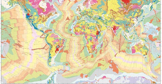
Rick asked me about the percentage of land not covered with sedimentary rock worldwide. I had said about 20% after AI told me between 20 and 25%. But after rechecking, I found that it’s likely actually about 30% or a little more. I found a good map of world geological topography and noticed that the areas where sediments were washed away fits Mike Fischer’s Shock Dynamics model well at NewGeology.us.
I’m adding this to the section of my online book, called 3200 BC GREAT FLOOD EVENTS.
CONTENTS
DIRECTIONS OF FLOOD WATER FLOWS
SOUTH TO NORTH PANGAEA SPLIT & OCEAN FLOW
WORLD SEDIMENT MAP
Here's a world map that shows geological topography:
https://www.pinterest.com/pin/45739752444284954/. The pinkish purple areas are where there is no sedimentary rock, because the Flood washed it into the oceans, because it was a bit higher land and the sediment on it was still soft and wasn't yet turned to rock. Here’s the same map with arrows to show directions of Flood water flow during the breakup of Pangaea.
DIRECTIONS OF FLOOD WATER FLOWS
The supercontinent Pangaea just started splitting up as a huge asteroid hit the east coast of Africa and the Atlantic and Indian Ocean basins started forming, opening up. So the Flood waters started flowing into those basins and they took a lot of sediment with them from north & east Canada, Greenland, Scandinavia, Brazil & west central Africa into the Atlantic basin and from southeast Africa, Madagascar, India, west Australia and maybe Antarctica into the Indian Ocean basin.
SOUTH TO NORTH PANGAEA SPLIT & OCEAN FLOW
Mike said the Atlantic basin opened up first in the south, so as the Flood waters started entering the basin from the south (by what is called West Antarctica attached to South America), the waters on South America and south Africa started pouring off of them into the Atlantic, but they soon ran into the waters from the south, so the sediments were confined to near the coast, building up the continental shelves.
As the Pangaea split continued northward, separating North America from west Africa & Europe, the sediments of Canada & Scandinavia began pouring over their coasts, until again meeting the waters coming from the south. This shows that India, Australia and most of Antarctica were connected to Africa.
NEW MOUNTAINS & MAGMA SPILLS
Mountains were forming at the same time as the ocean basins. The Rockies helped push the Flood waters eastward over east Canada (washing away most Flood sediments) and westward to the Pacific, but the Appalachian Mountains prevented the waters from removing as much sediments from the U.S. The only other pink area is in south Siberia north of eastern China, where the Flood waters must have been strong enough to remove sediment there into the Pacific, north of Japan. The red areas (below) indicate magma flow onto the land surface, called flood basalt, which are mainly in Washington, south Brazil, east central Africa, west central India, central China and central Siberia. Those are where the land rifted apart just enough to force a lot of magma through the cracks from under the continents.
(Note: the far north and far south are greatly distorted in the map, so Greenland looks about 14 times bigger than it really is. Likewise for Siberia, Scandinavia, Antarctica etc.)
Caves were also forming during the Flood, as explained here. All the above apparently happened about 3200 BC. The Younger Dryas Floods 700 years later added to the sediment erosion, but not nearly as much.
PANGAEA BREAKUP DURING FLOOD
I just wrote to Mike and said I concluded some years ago that the Pangaea breakup likely occurred during the Flood, because sedimentary rock in many mountainous areas is folded, suggesting the sediments were still soft when the mountains formed (which was during the Pangaea breakup). The only evidence I remember Mike mentioning for his view that the breakup occurred 300 years after the Flood is that Peleg means divided and he was 300 years after the Flood. But I think divided referred to the people or the language being divided at the time of the Tower of Babel about 300 years post-Flood.
SCALDING OCEANS
I think the Bible says there was rain for 40 days and nights at the beginning of the Flood. An Australian video guy said large meteor impacts in the oceans would have caused a lot of rain. It seems to me that when the Atlantic and Indian ocean basins formed, a lot of hot magma would have been exposed and would have caused a lot more rain as Flood and Ocean waters hit the magma. The 40 days of rain seems to have been caused by ocean impacts, but the Bible doesn't seem to mention rain after the first 40 days. So I'm guessing that the later rain wasn't recorded, or the Ark may have been in a drier area at that time. I think the Pangaea breakup had to be after the Flood had already deposited nearly all its sediments on Pangaea.


