

CATACLYSMS WORLD MAPS
Sediments, Ice Age, Craters ...

CONTENTS — FIND IN PAGE
CONTINENT & SEAFLOOR SEDIMENT THICKNESS
I decided to post these maps in order to try to have a convenient place to compare various events and features around the world. I may need to add more maps eventually.
GLOBAL BASINS
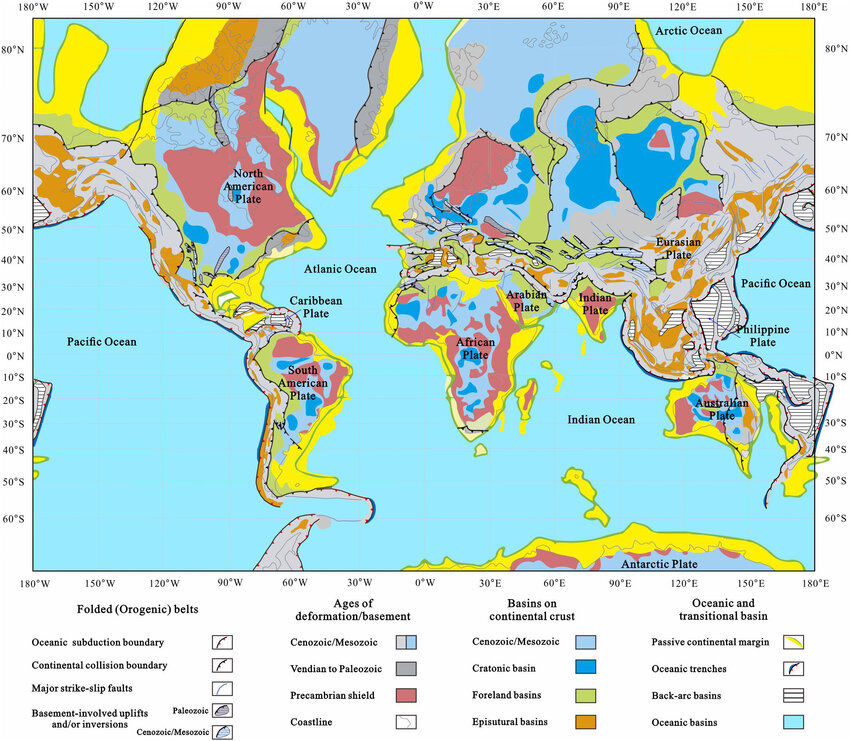
(Credit: https://www.researchgate.net)
Many Basins were meteorite impact sites during the Great Flood, according to Michael Oard. The dark pink areas are called Precambrian shield. The Flood deposited sediments on all of the continents, but it also washed away a lot of sediments as it receded. In the shield areas the sediment was entirely removed. In many other continental areas the sediments were only partly removed. Northern Canada lost most of its sediments, except in the area of Hudson Bay, because sediments tended to remain mainly in lowlands or basins.

(Credit: https://www.researchgate.net)
Basin Name--; Depth(mi); Area(mi²); P/M/C(%); Cont: Country
Wellenberg --- 1.2 ------ 1000 --- 60/100/100 ---- Eu: Switzerland
Duero --------- 1.9 ----- 19300 ---- 0/20/100 ------ Eu: Spain
Paris ------—-- 1.9 ----- 54000 --- 20/100/100 ---- Eu: France
Piceance ------ 2.5 ------ 6000 --- 70/100/100 ---- NA: W USA (CO)
San Juan ------ 2.5 ------ 7500 --- 70/100/100 ---- NA: W USA (NM-CO)
Santanghu ---- 2.5 ------ 8000 --- 60/100/80 ----- As: NW China
Qinshui ------- 2.5 ----- 10000 --- 80/100/100 ---- As: N China
Gippsland ----- 2.5 ----- 17000 --- 10/100/100 ---- Au: SE Australia
Green River --- 2.5 ----- 25000 --- 60/100/100 ---- NA: W USA (WY-CO_UT)
Taranaki ------ 2.5 ----- 37000 --- 10/100/100 ---- Au: New Zealand
East Texas ---- 2.5 ----- 50000 --- 100/100/90 ---- NA: S USA (TX)
Illinois -------- 2.5 ----- 60000 --- 100/90/90 ----- NA: C USA (IL-IN-KY)
Surat ---------- 2.5 ----- 80000 --- 20/100/100 ---- As: India
N German ---- 2.5 ----- 80000 --- 60/100/100 ---- Eu: Germany
Powder Riv --- 3.1 ----- 22000 --- 80/100/100 ---- NA: W USA (WY, MT)
Molasse ------- 3.1 ----- 32000 ---- 0/10/100 ------ Eu: Switzerland, Germany, Austria
Michigan ------ 3.1 ----- 58000 --- 100/100/100 --- NA: N USA (MI)
Pannonian ----- 3.1 ----- 60000 --- 20/100/100 ---- Eu: Hungary, Romania, Balkans
Dniep./Don. --- 3.1 ----- 60000 --- 100/100/80 ---- Eu: Ukraine, SW Russia
Denver --------- 3.1 ----- 66000 --- 80/100/100 ---- NA: C-W USA (CO, WY, NE, KS)
Bohai Bay ----- 3.1 ----- 78000 --- 60/100/100 ---- As: NE China
Llanos --------- 3.1 ----- 80000 --- 10/80/100 ----- SA: Colombia, Venezuela
Lusitanian ---- 3.7 ------ 8500 --- 10/100/100 ---- Eu: Portugal
Qaidam -------- 3.7 ----- 45000 --- 60/100/100 ---- As: NW China
Neuquén ------- 3.7 ----- 46000 --- 10/100/80 ----- SA: Argentina
Songliao ------- 3.7 ----- 90000 --- 60/100/100 ---- As: NE China
Ordos ---------- 3.7 ---- 100000 --- 100/100/100 --- As: NC China
Williston ------ 3.7 ---- 110000 --- 100/90/90 ----- NA: N USA, SW Canada (ND, MB, SK)
Timan-Pech --- 3.7 ---- 320000 --- 100/100/80 ---- Eu: NW Russia
Parnaíba ------- 3.7 ---- 370000 --- 80/80/20 ------ SA: NE Brazil
Anadarko ------ 4.3 ----- 50000 --- 100/100/80 ---- NA: S-C USA (OK, TX, KS, CO)
Magallanes ---- 4.3 ----- 52000 --- 10/100/100 ---- SA: Chile, Argentina
Junggar -------- 4.3 ----- 65000 --- 80/100/100 ---- As: NW China
Canning ------- 4.3 ---- 170000 --- 100/100/100 --- Au: NW Australia
North Sea ----- 4.3 ---- 220000 --- 60/100/100 ---- Eu: UK-Norway-Germany
Taoudeni ------ 4.3 ---- 430000 --- 100/20/10 ----- Af: Mauritania, Mali
Parana --------- 4.3 ---- 463000 --- 10/100/100 ---- SA: Brazil, Paraguay, Uruguay
Permian -------- 5.0 ----- 86000 --- 100/100/90 ---- NA: USA (TX, NM)
E Siberia ------- 5.0 ---- 600000 --- 100/80/60 ----- As: NE Russia
Perth ----------- 6.2 ----- 39000 --- 100/100/100 --- Au: SW Australia
NigerDelta ---- 7.5 ----- 29000 ----- 0/10/100 ------ Af: Nigeria
Sichuan -------- 7.5 ----- 77000 --- 100/100/100 --- As: SW China
Appalachian --- 7.5 ---- 185000 --- 100/50/30 ----- NA: E USA (NY-KY-GA)
Barents --------- 8.0 ---- 540000 --- 80/100/100 ---- Eu/As: Norway, NW Russia
Tarim ----------- 9.3 ---- 210000 --- 100/100/100 --- As: W China
W Canadian --- 9.3 ---- 540000 --- 100/100/100 --- NA: SW Canada (AB, BC, SK, MB)
W Siberia ------ 9.3 --- 1400000 --- 100/100/100 --- As: N-C Russia
Bengal -------- 12.4 ---- 142000 ----- 0/10/100 ----- As: India, Bangladesh
S Caspian ---- 13.0 ----- 39000 ----- 60/100/100 ---- As: Azerbaijan, Turkmenistan, Iran
* (P,M,C=Paleozoic,Mesozoic,Cenozoic=Old,Middle,Young Strata)
GEOLOGIC PROVINCES
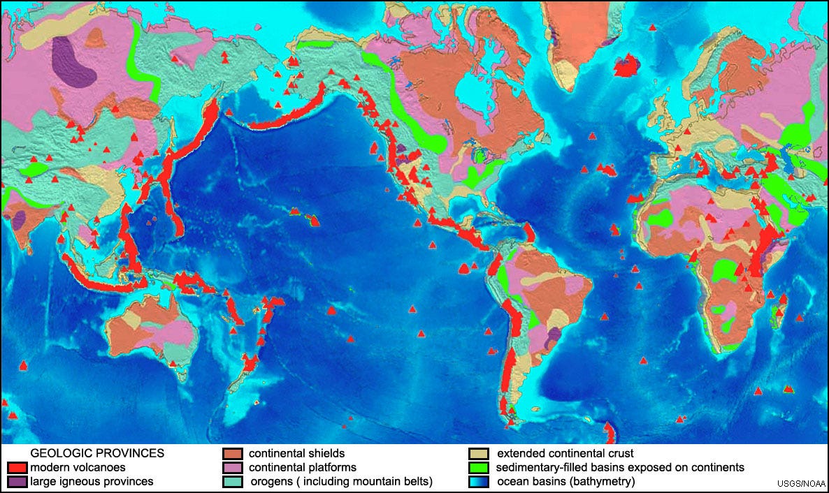
(Credit: https://gotbooks.miracosta.edu)
Fig. 6-20. Map of geologic provinces of the world. Sediments and sedimentary rocks not only cover much of the world's seabed but also cover large regions of the continents that were once under water.
Flood Basalts (dark purple above) are locations where large amounts of magma/lava flowed out from faults deep in the Earth’s crust (such as Argentina, India, Siberia, Washington State, East African Rift Valley, etc.). Flood Basalts are said to have formed in air on land, so it seems likely that they formed after the Great Flood. However, it seems that the Pangaea Breakup asteroid impact would most likely have been the cause of the Flood Basalts. But it seems that must have occurred about halfway through the period of the Great Flood. So this is a problem for me.
MARGINAL SEDIMENTS
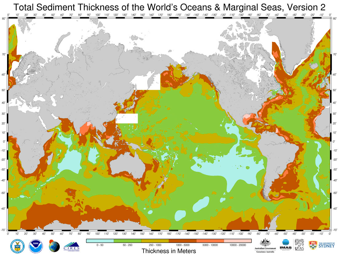
(Credit: https://gotbooks.miracosta.edu)
Fig. 6-17. Thickness of sedimentary deposits along continental margins.
Most of the sediments surely eroded off the continents in the recessional stage of the Great Flood.
SEAFLOOR SEDIMENTS
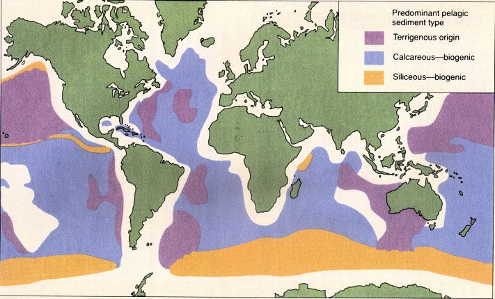
(Credit: https://gotbooks.miracosta.edu)
Fig. 6-18. Distribution of sediments on the seafloor by type.
Only the purple areas would be sediments eroded from continents, supposedly. However, I think the blue areas may be calcium sediments deposited during the Flood.
CONTINENT & SEAFLOOR SEDIMENT THICKNESS
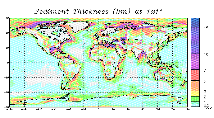
(Credit: https://igppweb.ucsd.edu/)
This global sediment map is digitized on a 1x1° scale. In the oceans, published digital high-resolution maps were averaged (e.g. Pacific, Indian and South Atlantic oceans). In areas for which such files are not available (e.g. Arctic and North Atlantic ocean), the sediment thickness was hand-digitized using atlases and maps. The sediment thickness in most of the continental areas (incl. shelves) were obtained by digitizing the Tectonic Map of the World provided by the EXXON production research group (1985).
The darker purple in the eastern Mediterranean Sea, and in the Black Sea, north of the Mediterranean, and in the Caspian Sea, east of the Black Sea, and also the area just north of the Caspian Sea, are shown as having deep sediments, meaning they’re basins where meteorite impacts likely occurred. The Gulf of Mexico along the coasts of Texas and Louisiana may also be an impact site, which is just north of the Chicxulub impact site on the tip of the Yucatan peninsula of Mexico.
ICE AGE

(Credit: https://vividmaps.com/wp-content)
Red crosses show impact crater sites (SE Louisiana, Lake Ontario, Lake Nipigon, Great Slave Lake, Great Bear Lake, Hiawatha Crater - NW Greenland — Source: Randall Carlson; Saginaw Bay, MI, not shown — Source: Antonio Zamora). All but one of the impacts hit the Ice Sheet and surely caused rapid meltwater flooding. The Himalayas, Alps, Andes and other mountain ranges were also glaciated. I don’t know yet if there’s evidence that cometary plasma plumes would have rapidly melted them as well. Sumeria was flooded, but it would have been either at that time, during the Younger Dryas, or later. If it flooded during the Y.D., it must have been older than Egypt’s first dynasty.